Maps show where El Niño will impact the most as UN issues 'urgent' warning
The exact areas the El Niño will impact this year have been revealed by an updated mapping system, just after the UN warned about the damage it’s set to cause the world.
This year has been plagued with updates about when the dreaded El Niño will occur in 2026, carrying on into 2027.
But now that its path and impact have been followed, and its trajectory has been solidified, it’s apparently set to ‘pour fuel’ on an increasingly warming world.
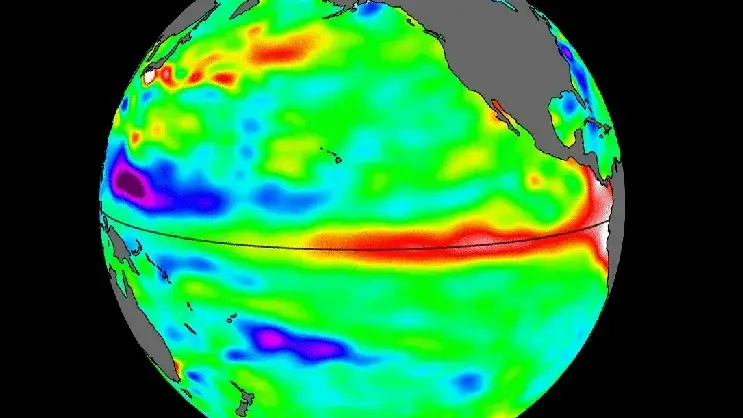
If you don’t know, an El Niño happens when the surface waters of the central and eastern tropical Pacific Ocean become unusually warm, which then goes on to influence global temperature and rainfall patterns – increasing the likelihood of risk of extreme weather, per the World Meteorological Organization (WMO).
Advert
Occurring between every two to seven years, and lasting somewhere around seven or nine months, its impact can be devastating to some regions.
Which we have now been made aware of.
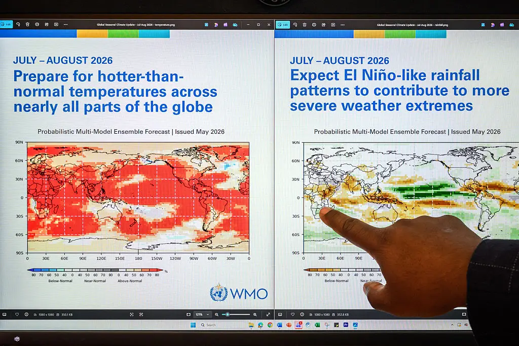
With this El Niño predicted to be the strongest in at least a decade, per National Geographic, a new WMO El Niño/La Niña Update shows there is an 80 percent likelihood of an El Niño event during June and August this year, continuing to around November.
The El Niño has been associated with increased rainfall in parts of southern South America, the south of the United States, parts of the Horn of Africa and central Asia, as well as causing drier conditions over Central America, northern South America, Australia, the Caribbean, Indonesia, and southern Asia, though worse events could happen.
For example, the WMO revealed that during the Boreal summer, ‘El Niño’s warm water can fuel hurricanes in the central/eastern Pacific Ocean, while it hinders hurricane formation in the Atlantic Basin’.
This risk can be catastrophic, depending on the strength of the hurricane formed.
Right now, the Greater Horn of Africa is likely to see below-normal rainfall across its northern Greater Horn of Africa during its rainy season from June to September.
While you might think less rain is a good thing, Africa's rain season is essential for things like crops, water sustainability and its economy.
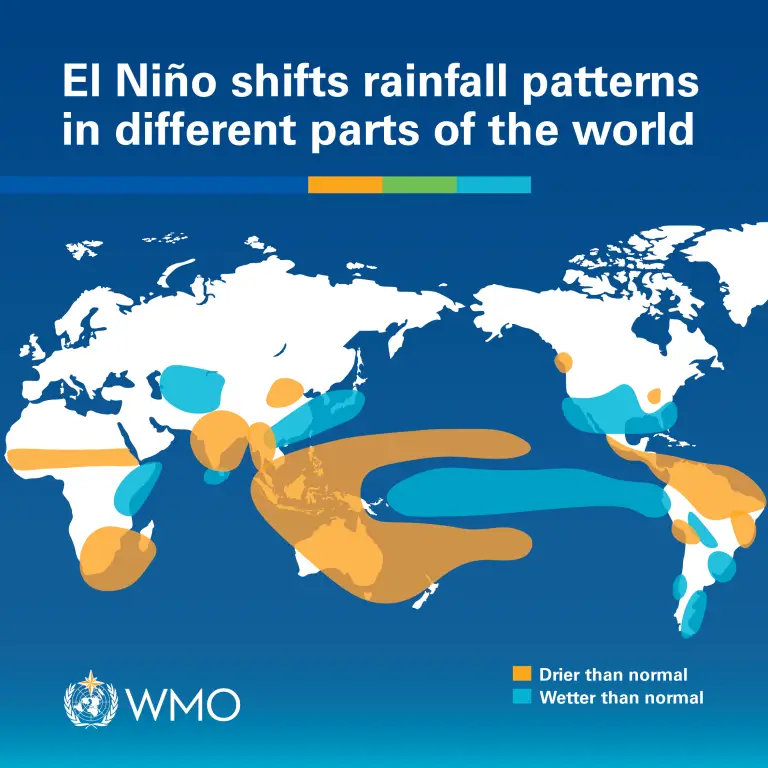
South Asia is also set to see below average monsoon rainfall, according to the South Asian Climate Outlook Forum, putting its reliance on monsoon water supplies at risk.
According to studies, South Asia relies on monsoon rainfall to provide 90 percent of its annual water, and if less is predicted to come, that means the region will have to find another water source to make up for the loss.
As for the Central America region, this instead should expect drier and warmer conditions, which can also cause things like droughts, heatwaves and more, per the BBC.
“The science is clear: El Niño is arriving on our doorstep in the coming months with 90 percent certainty. The world must treat it as the urgent climate warning it is", said UN Secretary-General António Guterres in a statement ahead of the El Niño.
He added: “El Niño conditions will pour fuel on the fire of a warming world. Impacts will hit even harder, travel even farther, and cross borders with devastating speed. The only effective response is climate action equal to the crisis – ending the addiction to fossil fuels, accelerating the shift to renewables, protecting the most vulnerable, and delivering early warning systems for all.”
WMO Secretary-General Celeste Saulo also went on to call for preparations to be made to keep everyone safe, noting: “We need to prepare for a potentially strong El Niño event – which will exacerbate drought and heavy rainfall and increase the risk of heatwaves both on land and in the ocean. The most recent El Niño, in 2023-24, was one of the five strongest on record and it played a role in the record global temperatures we saw in 2024.”
Topics: Weather, World News, US News
 Britt Jones