
Terrifying map reveals where drinking water is most polluted by ‘forever chemicals’ in the US
You might want to invest in a water filter after reading this.
Horrifying figures have been released which show a shocking level of pollution in the water coming out of our taps.
Maybe you're someone who insists on only bottled water, but if you're a fan of tap water, you might think twice after seeing this map.
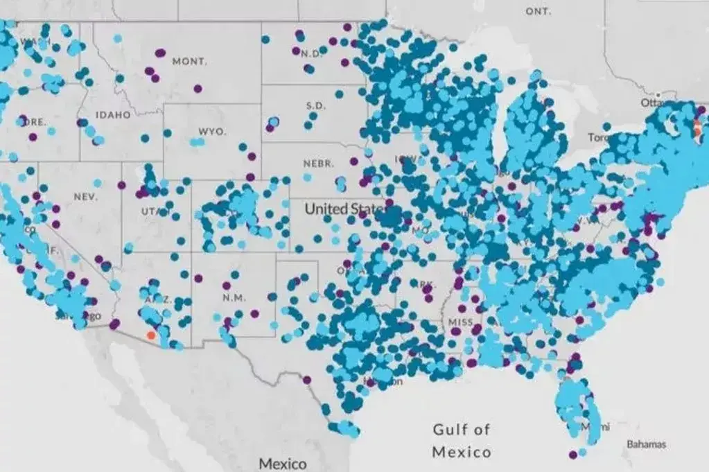
The new map reveals which places across the US have water tainted by PFAS, also referred to as 'forever chemicals'.
Advert
The data has been released by the Environmental Protection Agency (EPA), and it raises serious questions about the cleanliness of our water and also how modern living is tainting water sources.
The map highlights the areas in the country which suffer from the highest levels of PFAS contamination in drinking water systems.
PFAS are called 'forever chemicals' because of how long they last in the eco-system and because they are stubborn to remove.
They persist in the environment and the human body, and feature strong carbon-fluorine bonds. They transmit well through water too, which is another reason they are so difficult to get rid of.
According to the map, it's bad news for those living on the East Coast, as there are many more places there which came up with scarily high PFAS levels, well above the accepted limits.
The West Coast fared better, but there are still plenty of places to be concerned about it.
On the map, light blue areas show where at least one of these contaminants was found at higher than acceptable levels.
Dark blue means the levels are below the accepted amount.
There are 3,309 sites reporting PFAS in drinking water supplies, and the map doesn't reflect whether the regions are treating the water or if they're taking steps to reduce it.
According to the Mirror, the EWG said 'all locations represented on the map are approximate and intended to portray the general area of a contamination site or a community water system'.
Earlier this month, the EPA shared findings which showed an additional 7 million Americans were drinking water which has been contaminated with PFAS chemicals than the last time they tested.
The new figures brings the total to 172 million people according to Environmental Working Group (EWG)
The EPA told Newsweek: "On April 28, 2025, the agency announced a suite of actions to address PFAS, including in water. This list is the first, not the last, of all decisions and actions EPA will be taking to address PFAS over the course of the Trump Administration."
In light of the new discoveries, water processing facilities now have until 2027 to complete initial testing of PFAS chemicals.
Then, by 2029, all public water systems must have taken steps to bring the levels of PFAS chemicals down below maximum contamination levels.
Until that time, people in highly contaminated areas will have to try and fix things themselves.
The EPA hasn't yet revealed what the broad maximum contaminant level will be for water supplies.
However, they have specified the level allowed for individual chemicals, including: PFOA, PFOS, PFHxS, and PFNA.
The maximum contaminant levels are 4 parts per trillion (ppt) for PFOA and PFOS.
Elsewhere, it's 10 parts per trillion for PFHxS and PFNA.
The EWG recommends using water filters if you're in one of the worst areas.
Topics: Environment, Health, Science, Food and Drink, US News