Underwater drone discovers giant structures underneath antarctic ice before going missing
Topics: Science, Technology, World News, Environment, Climate Change, Antarctica
Topics: Science, Technology, World News, Environment, Climate Change, Antarctica
A research team has revealed its unmanned submarine picked up detailed images of an underwater glacier but the vehicle has since gone missing.
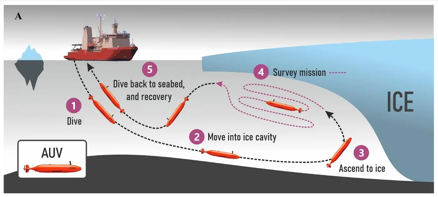
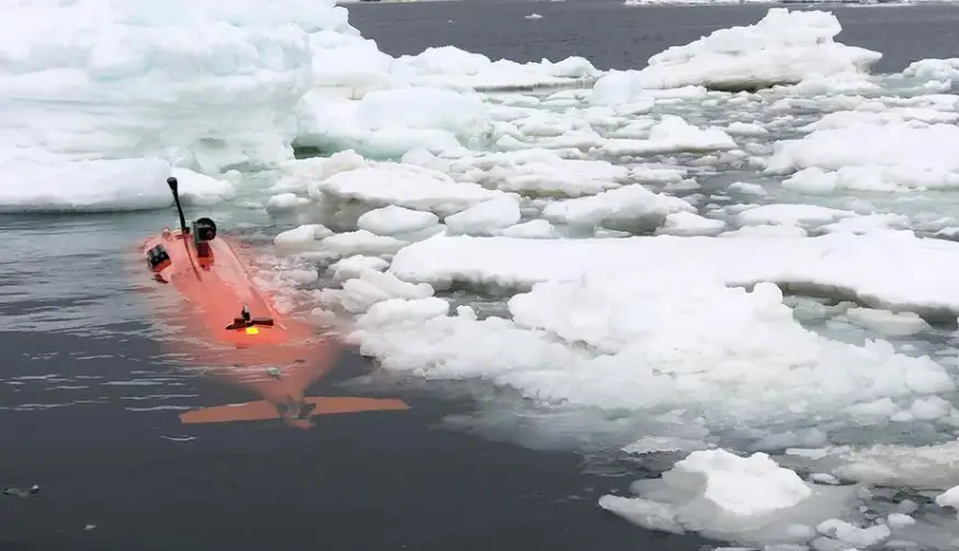
In January earlier this year, a team of researchers from the University of Gothenburg in Sweden traveled to Dotson Ice Shelf in Antarctica to repeat initial field work surveys conducted in 2022, sending an underwater drone called 'Ran' underneath and into a cavity of Dotson ice shelf in West Antarctica.
The Dotson ice shelf - a floating sheet of ice permanently attached to a land mass between Martin Peninsula and Bear Peninsula - was first mapped by the US Geological Survey in January 1947, however, the mapping was obtained via air photographs.
The University of Gothenburg's team has been working to map the ice shelf using underwater technology with the drone, named Ran, able to scan the ice above 'with an advanced sonar system,' the universities' website states.
Advert
Ran was programmed to dive into the cavity of the Dotson ice shelf and was underwater for 27 days, traveling over 1,000 kilometers to-and-fro under the glacier, as well as 17 kilometers into the cavity.
And the journey paid off - mostly.
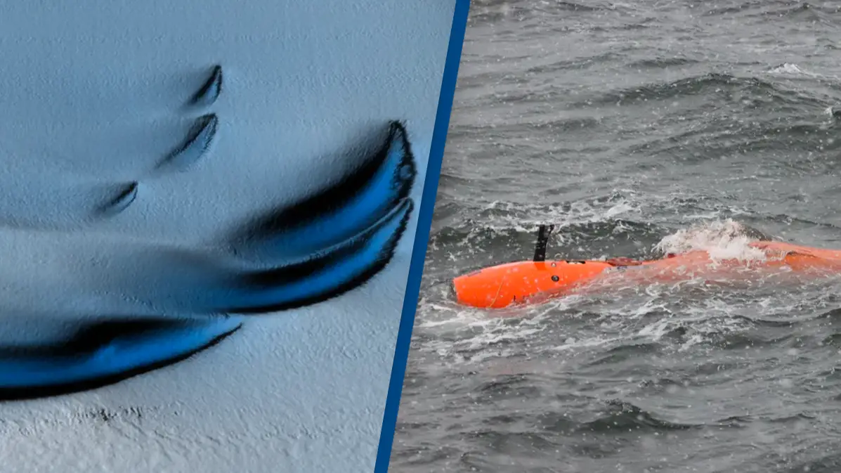
The underwater drone successfully collated the 'first detailed maps of the underside of a glacier'.
It revealed 'new patterns on the glacier base,' showing the surface 'is not smooth but there is peak and valley ice scape with plateaus and formations resembling sand dunes'.
"The researchers hypothesize that these may have been formed by flowing water under the influence of Earth's rotation," the survey added.
The mapping also showed the glacier 'melts faster where strong underwater currents erode its base'.
"Using the submersible, scientists were able to measure the currents below the glacier for the first time and prove why the western part of Dotson Ice Shelf melts so fast. They also see evidence of very high melt at vertical fractures that extend through the glacier."
Maps of the underside of a glacier are crucial in terms of revealing 'clues to future sea level rise'.
Professor of Oceanography at the University of Gothenburg and lead author of the study Anna Wåhlin explained teams have 'previously used satellite data and ice cores to observe how glaciers change over time'.
However, by using the underwater drone, they were 'able to get high resolution maps of the ice underside', which is 'a bit like seeing the back of the moon'.
Glaciologist from the University of Manitoba and co-author Karen Alley said the maps produced by Ran 'represent a huge progress in our understanding of Antarctica's ice shelves' and 'uncovered a more extensive and complete picture than ever before'.
Wåhlin noted there aren't 'many uncharted areas left on Earth', which makes Ran's exploration of the unknown depths below the ice even more exciting. However, the mission also led to Ran having 'disappeared'.
Wåhlin continued: "Experience from over 40 missions below ice gave us confidence but in the end the challenging environment beat us," she said.
However, that one dive and Ran's mapping which resulted from it has given researchers 'a lot of new data' to 'look at more closely'.
The professor resolved: "It is clear that many previous assumptions about melting of glacier undersides are falling short. Current models cannot explain the complex patterns we see. But with this method, we have a better chance of finding the answers.
"Better models are needed to predict how fast the ice shelves will melt in the future. It is exciting when oceanographers and glaciologists work together, combining remote sensing with oceanographic field data. This is needed to understand the glaciological changes taking place – the driving force is in the ocean.
"[...] Although we got valuable data back, we did not get all we had hoped for. These scientific advances were made possible thanks to the unique submersible that Ran was. This research is needed to understand the future of Antarctica’s ice sheet, and we hope to be able to replace Ran and continue this important work."