
Life-threatening storm warning issued for US states as Hurricane Erin changes direction
 Britt Jones
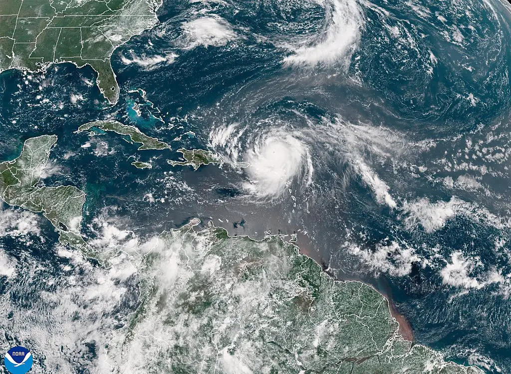
Hurricane Erin’s escalation from a tropical storm to a category five hurricane has sparked major warnings across seven states in the US, and surrounding countries as it changes path.
The storm was last noted to be moving northwest at 13 mph with maximum sustained winds of 100 mph, but further intensification hasn’t been ruled out.
Erin intensified to category five status on August 16 before being lowered to category three, but it is still expected to cause damage, according to NBC News.
The hurricane-force winds are expected to extend up to 90 miles from the center and tropical-storm-force winds to come up as far as 265 miles.
Advert
As the first Atlantic Ocean hurricane of hurricane season, Erin is looking to be a big one.
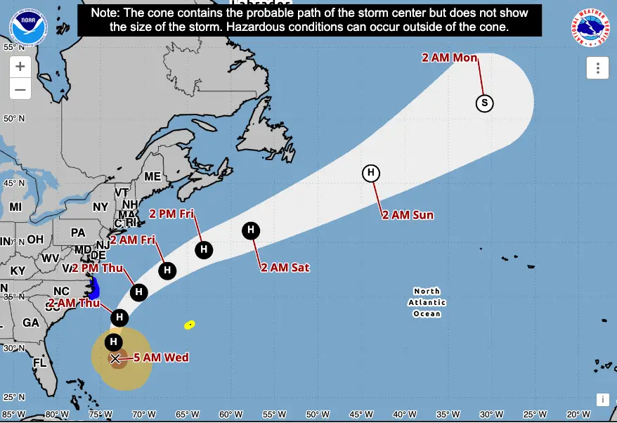
Erin’s path has been heavily monitored by numerous mapping organizations and websites.
Its path is inching west compared with previous forecasts, and though it's currently not expected to make landfall, this is still a possibility.
This morning (August 20), the NOAA warned the center of the hurricane is due to pass between the East coast and Bermuda from today through early Friday, then continue on past Canada.
The organization tweeted to its followers: “NOAA is monitoring water levels and winds for Hurricane Erin, which is expected to produce life-threatening surf and rip currents along the beaches of the Bahamas, much of the east coast of the U.S., Bermuda, and Atlantic Canada during the next several days.
"These rough ocean conditions are expected to cause life-threatening surf and rip currents."
The NHC said this morning that a storm surge warning was in effect for North Carolina's Outer Banks from Cape Lookout to Duck, along with a tropical storm warning over the next 36 hours for Beaufort Inlet, North Carolina to the North Carolina/Virginia border, including Pamlico and Albemarle sounds.
Just this weekend on Sunday (August 17), Erin’s outer edges hit parts of Puerto Rico and the Virgin Islands with heavy rains and winds, knocking out power for thousands of people.
Government officials in the Turks and Caicos Islands also confirmed all services were suspended on three of its islands as it ordered all residents to stay home.

Hurricane Erin is expected to cause chaos for many of the areas effected, particularly Bermuda.
While the island won’t feel the full intensity of the storm until August 21 (tomorrow) evening, acting Minister of National Security Jache Adams said, storm surge would make waters too dangerous to swim, surf or boat on.
Because Erin is expected to remain a large force until mid-week, the hurricane center’s Richard Pasch told PBS: “You’re dealing with a major hurricane. The intensity is fluctuating. It’s a dangerous hurricane in any event.”
The NHC's alert shared that water levels could rise two to four feet above ground along the North Carolina coast (Cape Lookout to Duck).
“The combination of a dangerous storm surge and the tide will cause normally dry areas near the coast to be flooded by rising waters moving inland from the shoreline,” the agency said. “The water could reach the following heights above ground somewhere in the indicated areas if the peak surge occurs at the time of high tide.”

The National Hurricane Center and Central Pacific Hurricane Center stated that it will be far too dangerous for beach-goers to swim in the ‘next few days due to life-threatening rip currents’ in the wake of Erin's new course of direction.
Because of the potential dangers, North Carolina officials declared a state of emergency and ordered mandatory evacuations for Ocracoke and Hatteras islands.
Even though Erin isn’t thought to be able to hit land at this rate, it very well could produce 20-foot waves and dangerous rip currents along the East Coast.
The storm and high waves could also lead to beach erosion, overwash and blocked roads.
The latest updates note that Erin is still growing in size, meaning that the tropical-storm winds are extending closer to the Mid-Atlantic and southern New England coasts at the tail end of this week.