States where 'Fujiwhara effect' is most likely to hit as experts warn it could be heading to US
 Britt Jones
The 'Fujiwhara effect' could be on its way to the US, and here’s which states could find themselves with devastating effects.
We have seen many natural disasters in the US recently, with many hurricanes causing destruction and chaos in their path.
Recently, we saw the fear caused by Hurricane Erin, and now the National Hurricane Center (NHC) is warning about Hurricane Gabrielle, which was confirmed to be a hurricane on Sunday (September 21).
The US is no stranger to the natural twisters, but the Fujiwhara effect is something new and horrifying.
Advert
It occurs when two large storms interact with one another.
So far, this year's tropical season in the Atlantic hasn’t seen much activity - with seven hurricanes recorded as of yet.
To constitute a tropical storm, it must reach winds of 34 knots, says the Met Office, and above that, it could become a scary force.
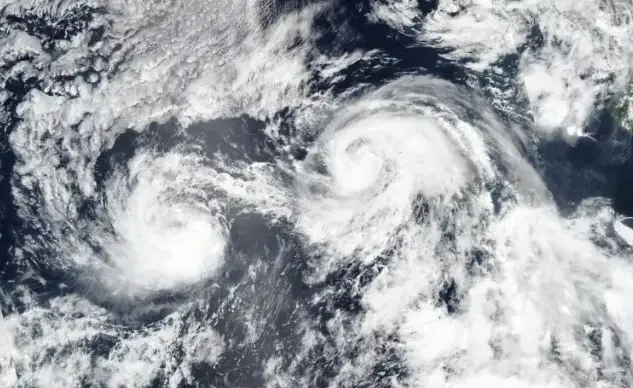
Sadly, there is an eighth named hurricane called Tropical Storm Humberto, which developed Wednesday (September 24).
As of right now, it is forecast to take a curved path between Bermuda and the East Coast of America, reports AccuWeather.
A ninth storm called Storm Imelda is also expected to come into fruition.
Humberto is expected to become a major hurricane this weekend, and in the case the two storms clash paths, this could mean very dangerous things for parts of the US.
As of right now, the East Coast and the Bahamas are expected to be impacted by the two storms.
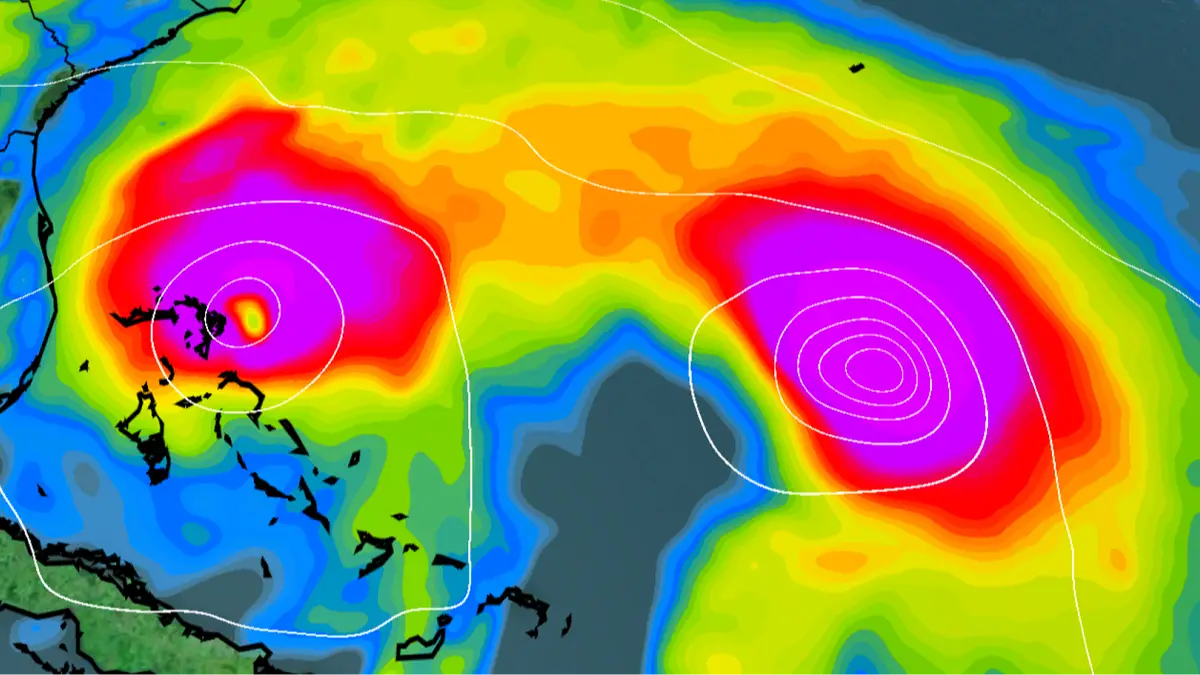
The phenomenon, which was named after Japanese meteorologist Sakuhei Fujiwhara in 1921, occurs when two cyclones come within 900 miles of each other and start spinning around a shared center.
Fox Weather meteorologist Greg Diamond told the NY Post: “The Fujiwhara Effect is when storms close together, interact, and rotate around each other.
“Or simply, they dance around each other. For tropical systems, the two must be within 900 miles of each other. For ‘ordinary,’ non-tropical storms, they need to be within 1,200 miles of each other.”
Depending on the strength and size of the cyclones, they could either smash together to create a mega cyclone, or they could absorb one another, or simply fade away.
While Humberto is rapidly intensify into a major Category 3 storm, and is expected to reach the level early next week, Imelda should cause Georgia and Carolina coasts to be shredded by damaging winds, a life-threatening storm surge and heavy flooding starting Sunday (28 September).
Tennessee Valley could also funnel abundant tropical-laden air into the Carolinas, parts of the southern and central Appalachians as well as the Mid-Atlantic next week, as per WPLG-TV hurricane specialist Michael Lowry, via USA Today.
He warned of an 'enhanced flood threat for these areas' that could start over the weekend.
Mike Boylan, storm chaser and founder of Mike's Weather Page, joined Fox's LiveNOW to share how he had been watching the movements of the two storms, noticing that even Florida could be impacted too, as he agreed with other experts on the areas to be effected.
“We're talking about the Fujiwhara effect as these two hurricanes interacting with each other, potentially pulling it out further to the Atlantic,” he said, adding: “But also, the possibility of pushing it to the coast of the Carolinas.”
The chaser explained that ‘you can see it potentially over South Carolina and North’, and also potentially tracking into Georgia.
But it's likely that the two storms could steer clear of one another, depending on how Imelda moves.
“When it comes to Humberto and soon-to-be Imelda, the higher-odds scenario now is that the large upper-level low-pressure system and front that’s producing the rain from the Gulf Coast to New England will pick up likely-Imelda and pull it north,” Diamond said.
“If this happens, likely-Imelda and Humberto maintain enough distance from each other that they don’t ‘Fujiwhara.'”